


Dr. Hugh Cutcher
March 18, 2026
Share this post
February delivered a continuation of January’s contrasting weather patterns across Europe, with a stratospheric warming event that disrupted the polar vortex, shaping cloud cover and irradiance patterns across the continent. Northeastern regions experienced colder, clearer conditions that lifted irradiance well above seasonal norms, while much of western and southern Europe endured persistent storms, heavy rainfall, and significantly reduced irradiance. The result was a strongly divided month for solar conditions, with notable positive anomalies across Scandinavia and the Baltic states offset by widespread deficits stretching from the UK to the eastern Mediterranean.
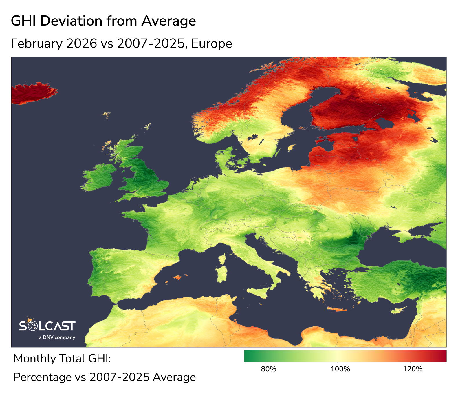
A major driver of this divide was a stratospheric warming event that split the polar vortex, establishing a blocking high-pressure system over northeastern Europe. This condition allowed cold, dry air to spill across the region, suppressing cloud formation and improving atmospheric clarity.
While the cold conditions reflected a continuation of the exceptional winter already underway – with January having delivered record-breaking cold across parts of the region – the associated dry air masses created favourable conditions for solar irradiance. Iceland, Norway, Finland, Poland and the Baltic states recorded irradiance levels around 20% above long-term averages. At these northern latitudes, February’s baseline global horizontal irradiance (GHI) remains relatively low, meaning that anomalies of this scale represent a substantial increase in the available solar resources.
While northeastern Europe saw clearer skies, the displaced polar vortex also pushed the jet stream further south, directing a series of storms and atmospheric rivers toward western Europe. This shift created a persistent cloud cover and rainfall extending from the UK and Iberian Peninsula through France, Italy and the Balkans to Turkey. Irradiance was suppressed across this entire corridor, with the most significant deficits concentrated in the UK, parts of the Black Sea coast, and Turkey. The pattern continued the storm-dominated conditions seen in January, with systems with storms Leonardo, Kristin and Marta each striking the Iberian Peninsula. These storms brought widespread flooding and landslides while maintaining thick cloud cover that suppressed solar irradiance across large areas of southern and western Europe.
At the national grid level, the impact varied significantly across Europe's major solar markets. Great Britain recorded February solar generation approximately 23% below the long-term average — its third-lowest February since 2008. France saw a 14% deficit, ranking as its fifth-lowest February on record. Germany experienced a more moderate 8% reduction, while Italy's deficit was just 3%, placing it near the middle of the historical range. The contrast between Great Britain and Italy highlights how the position of the storm track affected western-facing markets far more severely than the central Mediterranean.
Conditions began to shift slightly toward the end of February as a different blocking high developed over the Iberian Peninsula. This pattern brought a temporary break from the persistent storm track, allowing warmer temperatures and somewhat drier conditions to spread across western Europe. While this late-month shift improved irradiance levels compared with earlier weeks, the overall monthly pattern remained similar to January’s strongly divided conditions. Looking ahead, March is expected to gradually return conditions closer to seasonal norms across the continent, although models indicate that the UK, Benelux, northern France and northern Germany may continue to experience somewhat cloudier-than-normal conditions.
.png)
Track weather conditions, cloud movements, and irradiance-influencing factors that might impact your solar generation. Access bankable actuals and accurate forecasts when you sign up for a Solcast API toolkit. You can reach out to our team for an extended trial.